Introduction
Mining companies worldwide invest significant amounts in exploration and deposit appraisals. It is therefore imperative to have an efficient solution for managing end-to-end geoscientific exploration data. The Integrated Mineral Exploration Data Management Solution steps in to do the following:
Lack of Holistic View
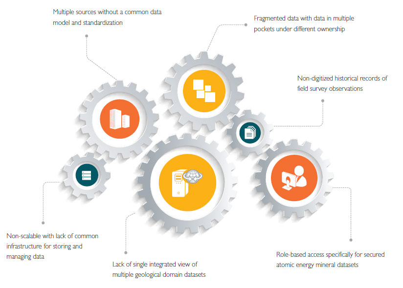
In the mineral exploration business a huge heterogeneity of geoscientific data in the form of geochemical, geophysical and geological data is managed in multiple systems. Lack of uniformity in access often results in non-availability of information to many stakeholders. It also prevents scaling up due to lack of common infrastructure.
Some of the key challenges in collating mineral exploration data are:

There is a need to comply with data interoperability and metadata standards such as Open Geospatial Consortium (OGC) and Federal Geographic Data Committee (FGDC). Open Geospatial Standards lay out yardsticks for defining Web Map Services interfaces that can readily be consumed by compliant platforms on the Internet. FGDC develops standards on different themes of geospatial data. Some of the other business challenges are real-time monitoring of field survey data,performing integrated search across multiple geoscientific domain data and providing secured role-based data access.
The solution looks at the exploration data landscape in its totality. It manages lifecycle of exploration data from field surveys to data quality checks and controls, data quality review and event-based notifications to management on the survey progress status.
Trusted Data
Ensures exploration data collected from surveys is reliable, accurate and interpreted through a formal review process. The data has been properly catalogued and its metadata has been defined and created as per international standards such as FGDC.
Common Platform
Provides one-stop shop for geoscientific data captured during field surveys. The platform supports open architectures such as SOA with high degree of flexibility on the choice of platforms both from HW and SW vendors. It comprises best-of-breed Geographical Information Systems productized solution developed as a Software as a Service (SaaS) model.
Process Integration
It is vital for operational efficiency. In the context of mineral exploration, it refers to integration of Field Survey Project processes with core Geoscientific Data Management solution and ensures smooth execution of projects. The data related to the Field Survey Projects are used for visualization on a dashboard for the management.
Common Infrastructure
It is a platform for future scalability requirements. It is centrally deployed and integrated with third-party platforms, both within and outside the enterprise. The infrastructure can be cloud hosted as an IaaS model based on the organization’s needs.
Enhanced Usability
Enables easy to use interfaces for visualization of integrated geospatial data cutting across multiple geoscientific domains.
Integrated Search
Enables capability to perform spatial as well as secure search operations on the enterprise mineral exploration data.

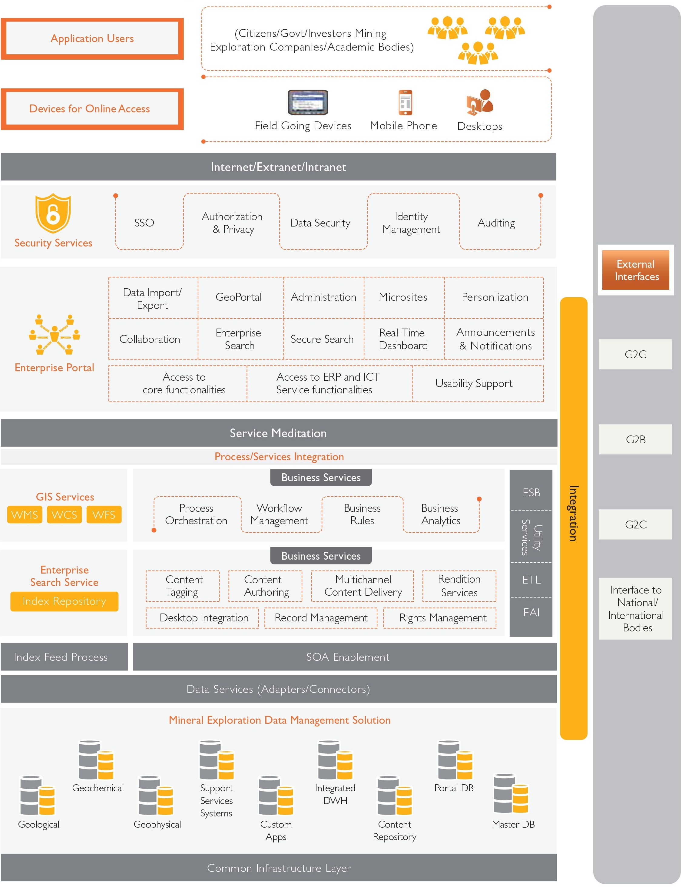
Figure 1: Conceptual Architecture
A conceptual architectural solution is shown in Figure 1. Its different layers are:
Data Repository Management
This layer provides APIs and connectors to multitudes of geoscientific data sources. The Spatial Data Engine is used to abstract the native data formats from the Web-based geo portal as well as other native client GIS applications. The unstructured content such as scanned images of geospatial maps get stored in Content Management repositories which can be accessed using metadata links. Real-time FSP project data and other geoscientific data can be stored in this layer.
Historical exploration as well as real-time data can be migrated to a data warehouse solution for providing intelligent decision-making capability. Tools are deployed to crawl multiple underlying geoscientific data sources for creating geoscientific metadata. This would enable spatial data searches including spatial extent and keyword searches. The typical metadata created are borehole geochemical data, sample reports, photos, topo sheet numbers, geological stream bed details, lithology, and mineralization data such as major or minor oxides. This geoscientific metadata gives the mining exploration companies much needed insights into geological, geophysical and geochemical composition of survey areas together with the mineral composition from the assay results.
Process and Service Integration
This layer caters to the GIS services, Business Services and Integration Services. GIS services refer to the Web Map Services, Web Coverage Services and Web Feature Services which help expose map data together with geoscientific data, features and geological layers onto a specialized Web portal.
Business Services refer to business rules definition for FSP, workflow management for data quality reviews, status monitoring and process orchestration specifically for collating lab samples results.
Integration services refer to data exchanges between third-party interfaces both internal/external to the enterprise.
Security Services
Enterprise data security at the application level to ensure confidentiality, integrity and availability is maintained. Security could be enabled at multiple levels at the data, application, end-user device and network as per the customer organization IT security policies.
Information Delivery System
Refers to the publication of WMS, WCS and WFS services onto native GIS client applications such as ESRI ArcGIS desktop®, Pitney Bowes MapInfo® to name a few. Apart from the native client applications, geoscientific map data should be projected on a geoportal for enhanced viewing experience.
The channels for consuming the processed geoscientific data are many; notable among them are mobile phones, field going devices with GPS and desktops.
How is Data Captured?
The solution provides an integrated approach to managing and disseminating exploration data to relevant sets of stakeholders. The data capture during a field survey project occurs in three ways.
Satellite Imagery Data
Space and airborne satellite data is used for identification of minerals. Specialized GIS applications are used to interpret the spectral signatures of the underlying mineral deposits, else mining organizations would have to buy the interpreted data from third-party sources.
The data captured by these modes undergo quality checks and are analyzed before metadata creation and publication as WMS onto the visualization layer.
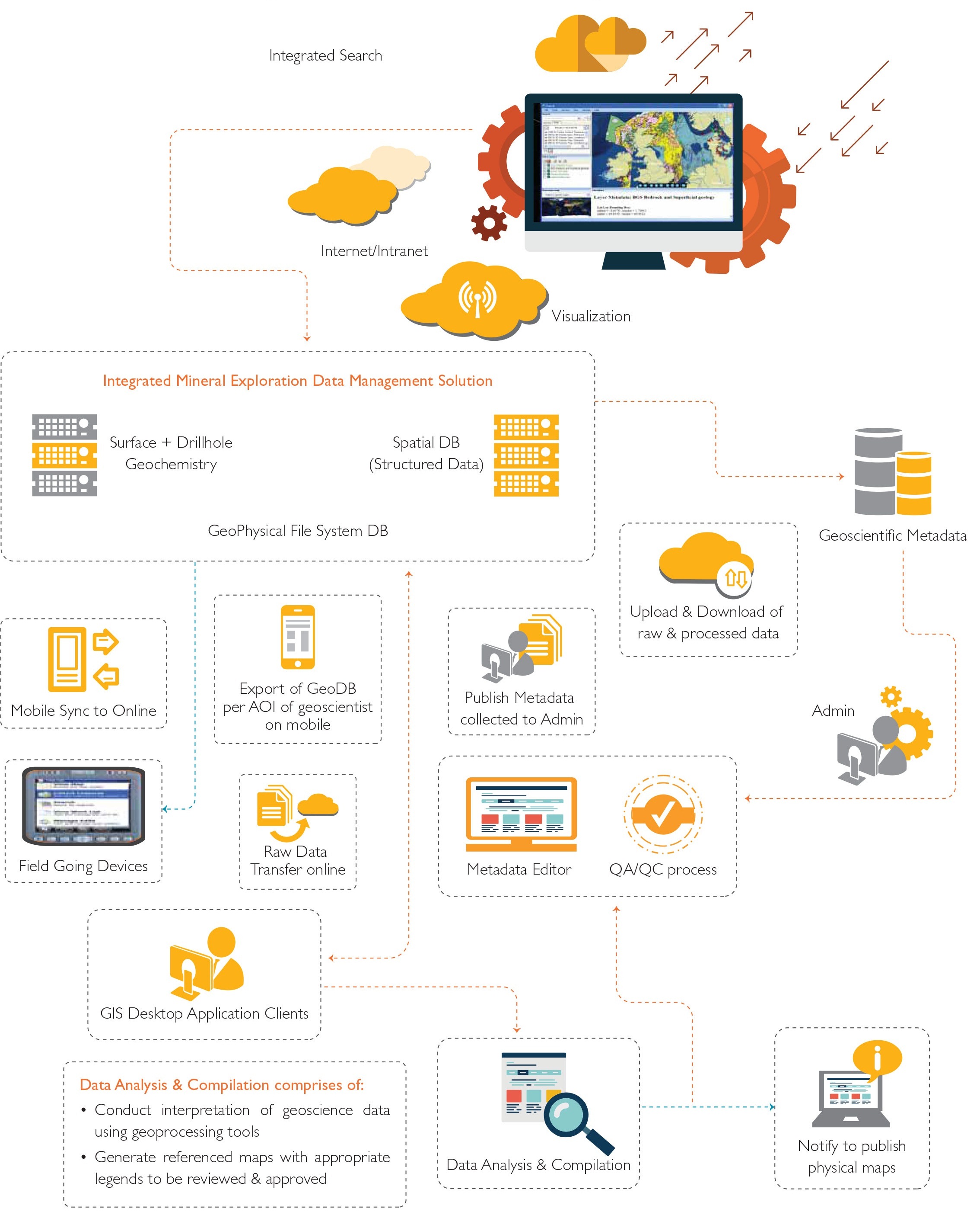
The data process flow diagram (See Figure 2) depicts how integrated mineral exploration data management solution helps in providing seamless consolidation and dissemination of exploration data.
Field Going Mobile Devices
Mobile applications running on Field Going Devices, which are handheld instruments with in-built GPS, are able to capture georeferenced data in online and offline modes. Pre-field survey information can be downloaded in a templatized format from the online geodatabase onto the mobile cache. This boosts field productivity due to reusing information collected from past surveys. Collaboration tools may also be considered for sharing ideas between field scientists and subject matter experts. The field geologists can synchronize the findings with the online server once connectivity is available.
Geoscientific Instruments
Field surveys require variety of instruments depending on the survey undertaken such as gravity, magnetic, borehole geochemistry to name a few. The data collected is dependent on the type of survey instrument which is stored in files as raw data.

Figure 2: End-to-End Exploration
Conclusion
The complexity and diversity of geosciences exploratory data is mind-boggling. The challenges are primarily to effectively manage and ensure data is trusted, reliable and is the single source of truth.
The life of a field geoscientist is made easier with this solution which enables field scientists to have templatized, readily downloadable geodata based on the area in which the exploration is being done.
Laboratory sample analysis plays a vital role in being able to do assay analysis on borehole data and coordinate with multiple labs across different locations seamlessly to provide the management with accurate results for future investments.
One of the key solutions is real-time monitoring of exploratory data collected as part of various field surveys.
A predictive and prescriptive analysis can be done using the exploratory data collected. It would provide trends in current and historical geoscientific data, its different correlation factors to determine probability of finding energy and non-energy mineral reserves.